Storm Dave is a deep area of low pressure that developed rapidly in the North Atlantic, drawing energy from a significant cold air plunge out of Canada. It was officially named by the UK Met Office on April 2, 2026 — a designation that reflects the storm’s potential to cause widespread disruption across the British Isles.
The name ‘Dave’ comes from a pre-agreed list of 21 names selected jointly by the Irish, British, and Dutch national weather services. Each name on the list is used in sequence whenever a storm meets the threshold for naming. Storm Dave is the fourth to reach that threshold this season, which gives you a sense of how active this weather year has been.
Key facts about Storm Dave at a glance:
- Officially named by: UK Met Office, April 2, 2026
- Season ranking: Fourth named storm of 2025-2026
- Primary hazards: Very strong winds, coastal gales, heavy rainfall, and blizzard conditions at elevation
- Peak impact window: Saturday evening, April 4, through early Easter Sunday, April 5
- Regions most affected: Scotland, Northern Ireland, Republic of Ireland, north Wales, and parts of northern England
Storm Dave Tracker Map: Where to Find Live Weather Updates and Radar
Real-time radar is your most valuable tool during a named storm. The storm’s exact track, speed, and intensity can shift as it makes landfall, so checking a live map every hour or so on Saturday is a smart move.
The Best Sources for the Storm Dave Live Radar and Storm Track Map
- Met Office (metoffice.gov.uk) — The UK’s official forecaster. Hourly radar updates, active warning maps, and the most authoritative path forecast for Storm Dave are all available here.
- Met Eireann (met.ie) — Ireland’s national weather service, with dedicated Storm Dave tracking and county-level warning information updated throughout the day.
- Windy.com — An excellent interactive global wind map that lets you visualise the storm system in real time. Ideal for seeing the storm’s structure and movement at a glance.
- BBC Weather — Accessible radar and regional forecasts that are updated regularly during active weather events.
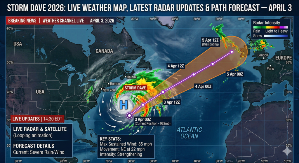
The Storm Dave path forecast radar map currently shows the storm’s centre of low pressure moving northeastwards across or just to the west of the Scottish mainland on Saturday night, then clearing into the North Sea through Sunday. Pay attention to the timing updates — warnings have already been adjusted once, and further changes are likely as the storm’s precise track becomes clearer.
Storm Dave Path Forecast: Where Is This Storm Headed?
Knowing where a storm is going — and when it will arrive — helps you plan around it effectively. Here is what forecasters currently expect from Storm Dave’s track.
Storm Dave’s Projected Route (April 4-5, 2026)
The low-pressure system at the heart of Storm Dave is forecast to approach the west coast of Ireland during Saturday afternoon, before moving north and northeast across or close to northwestern Scotland on Saturday evening and overnight. By Sunday afternoon, the storm should have cleared into the North Sea, allowing conditions to gradually improve across most of the affected region.
It is worth noting that the exact track still carries some uncertainty — as is normal with fast-developing Atlantic systems. Even a relatively small shift in the storm’s path could mean the difference between a glancing blow and a direct hit for any given area. This is why meteorologists are urging everyone in potentially affected regions to monitor forecasts frequently on Saturday rather than checking once and assuming the situation is settled.
Approximate Timeline of Storm Dave’s Arrival by Region
- Friday, April 3 (Good Friday): Unsettled and blustery across most areas, with heavy rain moving through and snow on higher ground in Scotland
- Saturday, April 4 from 1:00 PM to 2:00 PM: Wind warnings activate across Ireland and Northern Ireland; strong southerly winds begin to build
- Saturday, April 4 from 5:00 PM onwards: Warnings come into effect for north Wales and parts of northern England; conditions deteriorate rapidly
- Saturday evening through overnight: Storm at peak intensity across Scotland and the north; potential for very severe gusts in exposed locations
- Easter Sunday, April 5: Storm clears to the North Sea through the day; a brighter but still breezy afternoon is expected across most areas
Storm Dave’s Impact on US Weather Forecasts in 2026
While Storm Dave is primarily a European weather event, it is connected to a much larger atmospheric pattern that is relevant to observers and travellers on both sides of the Atlantic.
What Drives a Storm Like Dave? The North Atlantic Connection
Met Office Deputy Chief Meteorologist Dan Holley explained that a significant cold air plunge from Canada into the North Atlantic is what has energised this storm. That cold air mass strengthened the jet stream, which in turn spun up a deep area of low pressure and sent it tracking rapidly toward the British Isles. This kind of transatlantic weather mechanism is not unusual in spring, but the speed at which Storm Dave deepened — a process known as explosive cyclogenesis — is what makes it especially noteworthy.
How Storm Dave Affects Transatlantic Travellers
If you are flying between North America and Europe around Easter weekend, you should be aware that Storm Dave is generating rough conditions across the North Atlantic. Headwinds and turbulence on transatlantic routes may lead to slightly longer flight times, and some airports in Scotland and northern England could experience arrival or departure delays on Saturday evening. It is worth checking your flight status directly with your airline on the day.
Understanding Storm Dave Warnings: What the Colour Codes Mean for You
Both the Met Office and Met Eireann communicate storm risks using a straightforward colour-coded warning system. Here is what the current Storm Dave warnings actually mean in practical terms.
Yellow Warning — Be Aware
A Yellow warning is currently in place for most of the regions expected to be affected by Storm Dave. This level means that the weather has the potential to disrupt daily life and cause some damage, but widespread or severe impacts are not certain. You should be aware of the risk, keep an eye on updated forecasts, and take sensible precautions where you can.
Current Storm Dave Warning Summary (as of April 3, 2026)
- Republic of Ireland — All 26 counties: Status Yellow wind warning, Saturday 2:00 PM to 11:00 PM
- Northern Ireland — All six counties: Yellow wind warning, Saturday 2:00 PM to Sunday 2:00 AM
- Scotland — Yellow wind and snow warnings, Saturday evening through Easter Sunday morning
- North Wales (Anglesey, Gwynedd, Conwy, Denbighshire, Flintshire): Yellow wind warning, Saturday 5:00 PM to Sunday 7:00 AM
- Parts of northern England: Yellow wind warning, Saturday evening
Scotland faces the most serious conditions. Meteorologists have identified a real possibility of gusts reaching 80 to 90 mph in the most exposed locations in the northwest Highlands — and when combined with heavy snowfall, those winds could produce whiteout conditions on higher ground.
Severe Weather Map for Storm Dave: Regional Breakdown
Scotland
Scotland is directly in the path of Storm Dave’s most powerful phase. Gusts of 50 to 60 mph are expected across much of the country, rising to 60 to 70 mph in coastal and elevated areas. In the northwest Highlands, there is a real — if not guaranteed — risk of gusts between 80 and 90 mph for a short period. A separate snow warning covers northwest Scotland, where 10 to 20 cm of accumulation is forecast on higher ground. When combined with the strong winds, this creates blizzard-like conditions, drifting snow, and very poor visibility on mountain roads.
Northern Ireland
Counties Donegal, Derry, Antrim, Sligo, and Leitrim are expected to bear the brunt of the storm’s impact on Ireland’s northern coast. Forecasters at Met Eireann have specifically highlighted these areas as being in line for very strong winds through Saturday evening. Coastal flooding is a particular concern because spring tides are coinciding with the storm’s arrival, which amplifies wave heights and increases the risk of water overtopping sea defences.
Republic of Ireland
The western and northwestern coastline — including counties Galway, Mayo, Clare, and Donegal — faces the greatest exposure to wave overtopping and localized coastal flooding. Saturday afternoon’s high tide arrives at almost exactly the same time as the storm’s peak winds, which is a dangerous combination for low-lying coastal areas. The National Severe Weather and Flooding Coordination Group held a preparatory meeting on Thursday and has advised the public to stay away from exposed coastal areas throughout Saturday.
North Wales and Northern England
Strong southwesterly winds are expected to sweep through northern Wales and parts of northern England from Saturday evening onwards. Gusts of 50 to 70 mph are possible in exposed areas such as the Pennines and the North Wales coast. The main concerns here are road travel safety, particularly on elevated and exposed routes, and the risk of falling branches causing damage or injury.
How to Stay Safe Before and During Storm Dave: Practical Advice
Being prepared does not require much time or money — but it can make a real difference when a named storm arrives. Here is a practical checklist based on official guidance from the Met Office, Met Eireann, the Road Safety Authority, and the RNLI.
Before Storm Dave Arrives
- Check official weather warnings on the Met Office app or at met.ie and set up push notifications so you receive updates automatically
- Bring in or securely fasten any loose outdoor items — garden furniture, plant pots, trampolines, and wheelie bins can all become hazardous in high winds
- Clear gutters and downpipes of autumn debris to allow rainwater to drain freely and reduce the risk of overflows
- Charge all mobile devices and keep a portable battery pack handy in case of a power cut
- Stock up on a day or two of essential supplies — food, water, and any prescription medications — in case roads are temporarily impassable
- If you live near the coast, make a plan to be away from the shoreline during Saturday’s high tide window
Driving During Storm Dave
The Road Safety Authority has urged all drivers to slow down considerably in strong winds, maintain a greater following distance than usual, and never attempt to drive through flooded roads regardless of how shallow the water appears. The RAC has specifically warned that high-sided vehicles — lorries, vans, and motorhomes — are at significant risk of being pushed by buffeting gusts on exposed stretches of motorway and dual carriageway. If your journey is not essential on Saturday evening, the safest decision is simply to delay it.
Coastal Safety During Storm Dave
Large waves produced by named storms can catch people off guard, even when they are standing some distance from the water’s edge. The RNLI advises staying well back from sea walls, promenades, and cliff paths during the storm. Keep dogs on leads near cliff edges, and never assume a wave has finished just because the first one has passed. If you are ever swept into the water or you see someone else in difficulty, call 999 immediately and ask for the Coastguard.
FAQ:
Q.1. When will Storm Dave arrive, and how long will it last?
Answer: Storm Dave’s main impact period begins on Saturday, April 4, 2026, from around midday in western Ireland, building through the afternoon and reaching its most severe phase on Saturday evening and overnight across Scotland. Conditions will improve through Easter Sunday as the storm tracks away into the North Sea, with a broadly brighter — though still breezy — afternoon expected in most areas.
Q.2. Which parts of the UK and Ireland are most at risk from Storm Dave?
Answer: Scotland is the highest-risk region, particularly the northwest Highlands where gusts of 80 to 90 mph are possible in the most exposed locations. Northern Ireland, the western coast of Ireland, north Wales, and parts of northern England are all under active weather warnings and should take precautions seriously.
Q.3. Will Storm Dave disrupt Easter travel and flights?
Answer: Yes — significant travel disruption is expected across the warning areas on Saturday evening and overnight. Road travel should be avoided unless absolutely necessary. Scottish airports may experience delays or cancellations, and transatlantic flights could face headwinds and turbulence. Check with your airline or transport provider on Friday and again on Saturday morning before you travel.
Q.4. Where can I find the Storm Dave live radar and tracking map?
Answer: The most authoritative live radar and warning maps are available at metoffice.gov.uk and met.ie. For a more visual, interactive experience, Windy.com provides an excellent global storm tracker that updates in real time and clearly shows the movement of low-pressure systems like Storm Dave.
Q.5. Is Storm Dave unusual for April, or is this kind of storm normal?
Answer: Named storms in spring are not unheard of, but the speed at which Storm Dave deepened — driven by a powerful cold air intrusion from Canada — makes it stand out. The Met Office described it as a rapidly deepening area of low pressure, which means it intensified much faster than a typical Atlantic depression. That rapid development is what pushed it over the threshold for a formal naming.
Stay Informed, Stay Prepared, and Stay Safe This Easter
Storm Dave is a powerful and fast-moving weather system, and it is arriving at one of the busiest travel weekends of the year. The good news is that forecasters have seen it coming well in advance, warnings are in place, and there is plenty of time to prepare before conditions deteriorate on Saturday.
The most important thing you can do right now is stay informed. Bookmark the Met Office or Met Eireann website, enable weather alerts on your phone, and check for updates throughout Saturday rather than assuming the situation is static. Avoid unnecessary travel on Saturday evening, give coastal areas a wide berth during the afternoon high tide, and take a few minutes to secure your outdoor space before the winds build.
Storm Dave will pass. Easter Sunday should bring brighter conditions to most areas, and by Monday the worst will be well behind us. A little preparation now means you can enjoy the rest of the long weekend without any unwanted surprises.
For More Information
Related Article
29 NATO Nations Stand With Denmark After Trump’s Greenland Ultimatum — What’s Trump’s Next Move?
Blake Lively Claims Dismissed: What the Judge’s Ruling Means Before the May Trial
Gucci Mane Kidnapping Explained: Who Did It, Why It Happened, and What Comes Next
Hired to Kill: Inside the US Special Forces Mercenary Killing Unit Lawsuit and the UAE Connection
2 thoughts on “Storm Dave 2026: Live Weather Map, Latest Radar Updates & Path Forecast — April 3”