To understand the scale of what is happening, start with this number: nearly 94% of the Southeast is currently locked in severe to exceptional drought. The land is parched. The trees are dry. The swamps — which historically act as natural firebreaks — have dried out and are now burning alongside everything else.
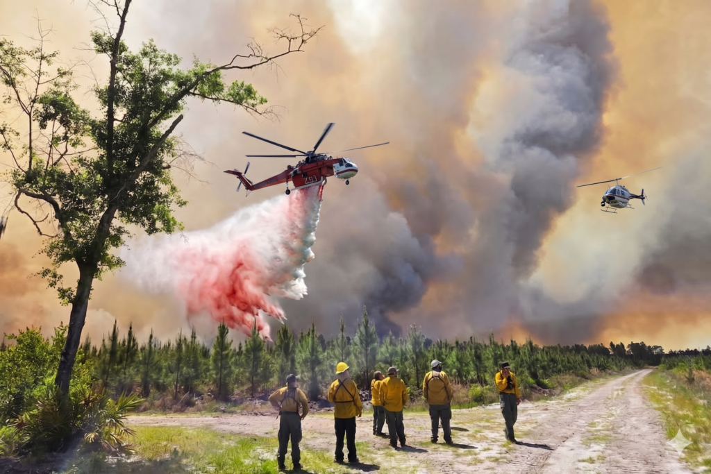
That is the backdrop against which two major wildfires ignited in late April. Together, the Highway 82 Fire and the Pineland Road Fire have wiped out more than 120 homes in southeast Georgia, with roughly 4,000 more still sitting inside active evacuation zones as of Friday. Georgia Governor Brian Kemp was direct about the reality firefighters are facing: there is simply no way to stop these fires outright. The strategy right now is to contain the flanks, protect as many structures as possible, and hope for a shift in the weather.
What makes this situation even more alarming is how it started. The Highway 82 Fire — now holding the grim distinction of being the most destructive wildfire in Georgia’s recorded history — was apparently ignited when a foil-coated party balloon drifted into a power line and sent a spark into the surrounding dry brush. The Pineland Road Fire started when a stray ember from a welding job landed in the forest. Two everyday moments. Two catastrophic chain reactions. That is what exceptional drought does — it turns small mistakes into disasters.
Fire-by-Fire Breakdown: Southeast Wildfire Tracker
Pineland Road Fire — Clinch and Echols Counties, Georgia
This is the larger of the two main fires. Burning near the Georgia-Florida border in Clinch and Echols counties, it has scorched more than 31,000 acres and sits at just 10% containment as of April 25. The fire originated from a welding spark and has been nearly impossible to slow down, largely because the wetlands and swamp areas it is burning through are completely desiccated. Those natural barriers are gone.
So far, the Pineland Road Fire has destroyed at least 35 homes and is threatening close to 160 more. Mandatory evacuation orders are in place for the Fruitland and Bamberg communities, and firefighting crews are battling extreme conditions — relative humidity hovering in the low 20s and a Keetch-Byram Drought Index approaching 700, which reflects just how critically dry the soil and vegetation have become.
Highway 82 Fire — Brantley County, Georgia
The Highway 82 Fire has burned approximately 9,578 acres and is about 10% contained as of today. What it lacks in size compared to the Pineland Road Fire, it more than makes up for in destruction. At least 87 homes have been confirmed destroyed — more than any wildfire in Georgia’s history — and the number continues to climb as damage assessment teams work their way through the affected areas.
Fire crews from Brantley, Glynn, and Effingham counties are working together to hold the perimeter. U.S. Highway 82 has since reopened, but Brantley County schools remain closed, and around 4,000 residents are still under mandatory evacuation.
Florida Wildfire Emergency Updates
North Florida is dealing with its own wave of dangerous blazes. The most heartbreaking development came on April 23, when Nassau County volunteer firefighter James “Kevin” Crews suffered a medical emergency while battling the Old Dixie Highway Fire near Hilliard and later passed away. That fire has since been brought largely under control, but it came at a devastating human cost.
In Clay and Putnam counties, crews have been making better progress on the Railroad wildfire, which stood at roughly 4,406 acres and 65% containment as of Friday. That is a far more encouraging picture than what is happening across the border in Georgia. Still, 38 Florida counties are operating under burn bans, and the state’s drought — described by officials as the worst in a quarter century — is not going anywhere soon.
Georgia Wildfire Evacuation News: Who Needs to Leave and Where to Go
If you are in Brantley County right now, you need to pay close attention to this section. Evacuation orders are being updated multiple times a day, and the consequences of ignoring them are severe.
The Georgia Emergency Management Agency has issued a mandatory evacuation covering the stretch of Highway 110 between Highway 32 and Lane Cemetery Road, extending from Lisa Lane to the Satilla River. Additionally, a voluntary evacuation covers the U.S. 301 corridor from the county line to Rowell Road — west of Highway 110, north to Highway 32, and east of Highway 110 to the county line.
Specific communities under mandatory evacuation include Happy Hollow, Hawks Landing, and Drury Court. Residents in all of these areas are directed to use Highway 32 as their evacuation route — do not try to navigate around the fire using other roads, as conditions can change within minutes.
For residents who have nowhere to go, a Red Cross shelter is open in Brunswick offering air-conditioned space and meals. The shelter is also now housing small pets — dogs and cats — in crated spaces, with bedding and crates provided at no cost. If you have livestock or large animals, the Georgia Department of Agriculture has posted designated care facility locations on its official website.
Wildfire Smoke Alert Southeast US: How Far Is the Haze Reaching?
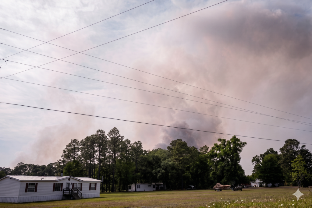
Here is something that often gets overlooked during a wildfire emergency: you do not have to be anywhere near the flames to be harmed by them. Wildfire smoke is its own public health crisis, and right now it is drifting well beyond the Georgia and Florida state lines.
Air quality monitoring stations across the state of Georgia were reporting moderate to unhealthy readings by midweek. The worst conditions are currently concentrated around Savannah, Georgia, and Columbia, South Carolina. Active air quality alerts are in effect for eastern Georgia, the Jacksonville area, and much of the Carolinas.
Protecting yourself from smoke exposure is straightforward, but only if you know what to do:
- Stay indoors with windows and doors shut, especially during peak burn hours
- Wear a KN95 or N95 respirator mask any time you go outside — standard cloth masks offer very little protection against wildfire smoke particles
- Set up a clean room in your home using a portable air purifier with a HEPA filter to maintain breathable air inside
- Switch your HVAC system to recirculation mode and fit it with a high-efficiency filter to prevent outdoor smoke from being pulled in
- Check AirNow.gov before any outdoor activity — the Air Quality Index (AQI) there is updated in real time
The people most at risk are children, older adults, and anyone living with asthma, COPD, heart disease, or other respiratory conditions. If you or someone in your home experiences shortness of breath, chest tightness, or worsening coughing, contact a healthcare provider right away.
Live Wildfire Map Georgia Florida: Best Tools for Real-Time Tracking
In a fast-moving wildfire situation, information that is even a few hours old can be dangerously outdated. Here are the most reliable, frequently updated resources to use:
For Georgia fires: The Georgia Forestry Commission at gatrees.org runs an interactive wildfire map that is updated throughout the day with current fire perimeters, containment status, and burn ban information. The Georgia Emergency Management Agency at gema.georgia.gov is the go-to source for official evacuation orders and county-level emergency declarations.
For Florida fires: The Florida Forest Service publishes an active fire map through the Florida Department of Agriculture and Consumer Services at fdacs.gov. This map shows current fire locations, acreage, and containment levels across the state.
For both states: The Watch Duty app — available free on iOS and Android — pushes real-time wildfire alerts based on your location and allows you to track multiple active fires simultaneously. The National Interagency Fire Center at nifc.gov also maintains a national-level view of all significant fires burning across the country.
Save these links now. Searching for emergency information during an evacuation is not a situation anyone wants to be in.
The Historic Drought Fueling the Georgia Forest Fire Emergency
People sometimes ask why wildfires in the Southeast feel so much worse lately. Part of the answer lies in the drought data.
Governor Kemp’s state of emergency covered 91 of Georgia’s 159 counties — more than half the state — because the drought is that widespread. The Florida Panhandle has been classified as a D4 drought zone, the most severe level on the U.S. Drought Monitor scale, which signals extreme fire risk and rapid groundwater decline. Much of northern Florida sits in a D3 zone just below that.
What this means on the ground is that the natural systems that normally keep wildfires in check are not working. Wetlands that would slow fire spread are dry enough to burn. Swamps that once acted as natural firebreaks are now contributing fuel. Firefighters say it is like trying to battle a fire in a landscape that has been pre-treated to burn.
Scientists point to a convergence of contributing factors: months of well-below-average rainfall, gusty and persistent winds, the residual dead timber left behind by earlier storms, and broader climate trends that are making drought conditions more frequent and more intense. Georgia’s Georgia Forestry Commission reported responding to 34 new wildfires in a single day during this outbreak — none of which included the two major fires already burning. This level of fire activity across a single state in a single day is extraordinary.
The burn ban now covering all 91 counties under the state of emergency is the first of its kind in Georgia’s history. No outdoor burning of any kind is permitted — not yard debris, not recreational fires, not anything involving an open flame.
Real Stories from the Georgia Wildfire Zone: What Survivors Are Facing
Statistics matter, but they do not fully capture what it feels like to leave your home in five minutes and not know whether it will still be standing when — or if — you return.
Many Brantley County residents described being caught off guard by how quickly the fire moved. One grandmother recalled hearing fire trucks rolling down her road, telling everyone to get out immediately. She grabbed her medications, her phone, and a charger, then left everything else behind. That was it.
Across the affected communities, the response from neighbors has been remarkable. Local restaurants opened their doors to displaced families and provided free meals. Church congregations organized donation drives. Neighbors with extra room opened up their homes to people who had nowhere to go.
Meanwhile, business owners who lost their livelihoods are worried about more than just rebuilding — they are wondering who will still be around to return once the fires are out. These communities are small. The losses are not abstract. They are personal, and they are deep.
FAQ :
Q.1. Which Georgia counties are currently under evacuation orders?
Ans: As of April 25, 2026, mandatory evacuation orders are active in Brantley County — covering communities including Happy Hollow, Hawks Landing, and Drury Court — as well as portions of Clinch and Echols counties tied to the Pineland Road Fire. Glynn County has declared a local state of emergency and is asking residents in certain areas to be ready to leave at short notice. Because orders are being updated frequently, always confirm the latest status with the Georgia Emergency Management Agency at gema.georgia.gov or by contacting your county’s emergency management office directly.
Q.2. Where can I find a real-time wildfire map for Georgia and Florida?
Ans: For Georgia, the Georgia Forestry Commission’s interactive map at gatrees.org is the most frequently updated official source. For Florida, use the Florida Forest Service map at fdacs.gov. The Watch Duty mobile app is also highly recommended — it covers both states and sends location-based push alerts when new fires ignite or existing fire perimeters expand.
Q.3. Is it safe to breathe the air in Georgia and Florida right now?
Ans: In many areas, no — at least not comfortably or safely for extended periods. Air quality readings across the region range from moderate to unhealthy, with the most hazardous conditions near Savannah and along the Georgia-South Carolina border. Before spending time outdoors, check your current AQI at AirNow.gov. If the reading is above 100, limit outdoor exposure. Above 150, stay inside with air filtration running whenever possible.
Q.4. What actually caused these wildfires in Georgia in 2026?
Ans: Both major fires were triggered by small, accidental ignition sources — but the root cause is a historic drought that has made the entire landscape dangerously flammable. The Highway 82 Fire ignited when an aluminum-coated party balloon made contact with a power line and sent sparks into the surrounding dry vegetation. The Pineland Road Fire started when an ember from nearby welding work landed in the forest. Under normal moisture conditions, neither incident would likely have grown beyond a manageable brushfire. The drought turned both into catastrophes.
Q.5. What should I do the moment I receive an evacuation order?
Ans: Do not delay and do not second-guess the order. Leave immediately. Grab your prescription medications, government-issued ID, insurance documents, phone and charger, enough water for a day, and your pets. Follow the designated evacuation route — for most of Brantley County, that means Highway 32. If you have no place to stay, head to the Red Cross shelter in Brunswick. If you become trapped and cannot evacuate, call 911, give your exact location, and turn on every light in your home to help rescuers find you. Do not attempt to shelter in place near an active fire.
Stay Informed, Stay Ready, and Don’t Wait
The Georgia Florida wildfires 2026 are not a situation that is going to resolve itself in the next few days. With the two main fires barely 10–15% contained, no meaningful rain on the forecast, and thousands of homes still in the danger zone, this emergency has a long way to go before it is over.
If you are anywhere in southeast Georgia or northeast Florida, take this seriously. Monitor official updates. Follow evacuation orders the moment they are issued. Protect yourself and your family from the smoke even if the nearest flame is miles away.
For More Information
Related Article
2026 NFL Draft Day 2 Shocking Picks: Carson Beck, Nate Boerkircher Leave Analysts Stunned
NFL Draft 2026 Live Tracker: Round 1 Picks, Trades, and Biggest Surprises as They Happen
Baton Rouge Mall of Louisiana Shooting: Teen Killed, 5 Injured After Food Court Gunfight